MITTAL INSTITUTE OF TECHNOLOGY & SCIENCE, PILANI
Global Navigation Satellite System (GNSS)
Introduction
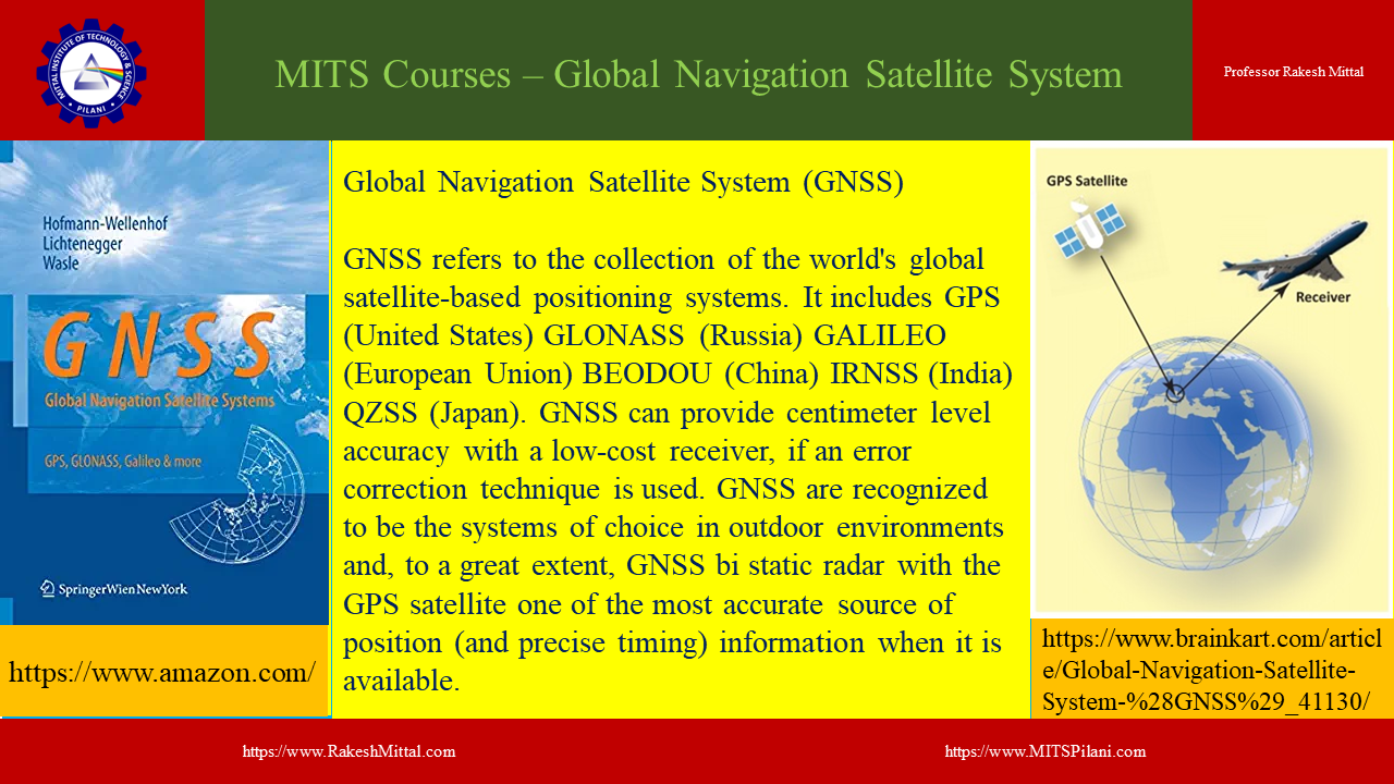
The Global Navigation Satellite System (GNSS) refers to a constellation of satellites that provide signals from space, enabling GNSS receivers to determine location (geographic coordinates), velocity, and time almost anywhere on Earth. GNSS encompasses several satellite navigation systems, such as the United States’ Global Positioning System (GPS), Russia’s GLONASS, China’s BeiDou, and the European Union’s Galileo system. GNSS has become a vital technology in various sectors, including transportation, telecommunications, agriculture, military operations, and scientific research.
Historical Development of GNSS
The development of GNSS began with the U.S. Department of Defense’s GPS program in the 1970s, primarily for military applications. GPS became fully operational in the 1990s, providing civilian users with free, accurate positioning services. Russia followed with the development of GLONASS, which became fully operational in the early 2000s. Since then, other global players like China and the European Union have launched their own GNSS systems, expanding the coverage and accuracy of satellite navigation services globally.
Components of GNSS
A typical GNSS consists of three main segments: the space segment, the control segment, and the user segment.
- Space Segment: This refers to the constellation of satellites orbiting Earth, which transmit radio signals to GNSS receivers. These satellites are distributed in such a way that, at any point on Earth, a user can receive signals from multiple satellites at once, enabling accurate location calculation.
- Control Segment: This consists of ground-based stations that monitor and control the satellites, adjusting their orbits and clock settings to maintain accurate signals. The control stations track the health and status of satellites and update the satellite data to ensure accuracy.
- User Segment: The user segment comprises GNSS receivers, such as smartphones, GPS devices, and systems installed in cars, aircraft, and ships. These receivers pick up signals from the satellites and, by calculating the time taken for the signals to travel, determine the user’s position, velocity, and time.
Working Principle of GNSS
GNSS works by utilizing the concept of trilateration. A receiver needs signals from at least four satellites to accurately calculate its position. Each satellite continuously transmits a signal containing the satellite’s position and the time the signal was sent. The receiver measures the time delay between when the signal was sent and when it was received. Using the speed of light, the receiver calculates the distance to each satellite. By knowing the positions of the satellites and the distances to them, the receiver computes its own position on Earth’s surface.
Types of GNSS
- GPS (Global Positioning System): Operated by the U.S. government, GPS is the most widely used GNSS globally. It provides highly accurate positioning, navigation, and timing information to both civilian and military users.
- GLONASS (Global Navigation Satellite System): Managed by Russia, GLONASS is similar to GPS and provides global coverage. Its accuracy improves when used in combination with GPS.
- BeiDou: China’s GNSS, known as BeiDou, provides regional coverage with plans for full global service. It offers enhanced features for users in Asia and has been expanding its reach internationally.
- Galileo: Galileo is the European Union’s GNSS, designed to provide highly accurate global positioning services, independent of other GNSS systems. It also offers an encrypted service for governmental and military use.
Applications of GNSS
- Transportation: GNSS is widely used in land, sea, and air navigation. It enables real-time tracking and routing for vehicles, ships, and aircraft, enhancing safety and efficiency. In aviation, GNSS is essential for precise landings and navigation during adverse weather conditions.
- Agriculture: Precision agriculture relies heavily on GNSS for applications such as automated tractor guidance, crop mapping, and efficient resource management. Farmers use GNSS data to optimize the use of seeds, water, and fertilizers, improving crop yield while reducing costs.
- Telecommunications: GNSS plays a critical role in synchronizing time for telecommunications networks. Accurate time stamping is essential for mobile phone networks, data transmission, and internet services.
- Surveying and Mapping: Surveyors use GNSS for accurate land measurements, infrastructure planning, and construction. GNSS has revolutionized geodesy and cartography by providing precise global coordinates for mapping and monitoring Earth’s surface.
- Disaster Management: GNSS is invaluable in disaster management, providing real-time location data for rescue and relief operations during emergencies such as earthquakes, floods, and hurricanes. It helps emergency responders reach affected areas quickly and efficiently.
- Military and Defense: GNSS was initially developed for military purposes and remains crucial for defense operations. It is used for navigation, missile guidance, reconnaissance, and the coordination of military forces.
- Space Exploration: GNSS plays an essential role in space exploration, aiding spacecraft navigation and tracking. It is used to monitor satellites, the International Space Station, and missions to other planets.
Challenges of GNSS
Despite its widespread use, GNSS faces several challenges. These include signal interference, such as jamming and spoofing, where false signals are sent to mislead GNSS receivers. Urban areas with tall buildings, dense forests, and mountainous terrains can obstruct satellite signals, leading to reduced accuracy. Moreover, reliance on a single GNSS system can be risky due to potential system failures or political conflicts, which is why many systems today combine data from multiple GNSS constellations for improved accuracy and reliability.
Future of GNSS
The future of GNSS looks promising, with continuous advancements in satellite technology, signal processing, and receiver design. Efforts are underway to enhance the precision of GNSS, potentially reaching centimeter-level accuracy. Multi-GNSS receivers that can process signals from various constellations are becoming more common, improving positioning accuracy and reliability. GNSS is expected to play a significant role in emerging technologies like autonomous vehicles, drone navigation, and smart cities.
GNSS is a transformative technology that has revolutionized how we navigate, communicate, and interact with our environment. Its broad range of applications makes it indispensable in modern life, and ongoing advancements will only enhance its capabilities. However, challenges like signal interference and dependency on specific systems require continuous innovation and collaboration across global stakeholders. As GNSS continues to evolve, it will remain a critical infrastructure for global development and innovation.
Professor Rakesh Mittal
Computer Science
Director
Mittal Institute of Technology & Science, Pilani, India and Clearwater, Florida, USA